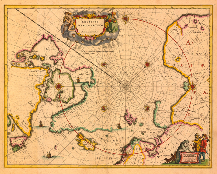
"Regiones Sub Polo Arctico" [ca. 1638]. Copperplate map, 39.4 x 51.1 cm., handcolored, with French text on verso. First state, from the French Appendice to Blaeu's Le theatre du monde. [Historic Maps Collection: purchased with funds provided by Robert M. Backes, Class of 1939.]
Identical to a 1637 map published by Jan Jansson, this version reflects the duplicative nature of the Dutch map trade at the time: generations of publishing-family members shared and reused plates. The only difference here is that Blaeu has put his scale in the lower-right cartouche where Jansson had his imprint. Cartographically, the map incorporates the major English discoveries of Henry Hudson and William Baffin, as well as those within Hudson Bay of Thomas Button and Thomas James. Here, though Frobisher's Strait is still mistakenly identified with Greenland, Frisland has disappeared. The curved rhumb lines radiating from the North Pole present a new polar map feature, suggesting compass-directed routes across the area. Images of wind heads, a naked cannibal, and a European cooking something in a brazier surround the title cartouche; some have suggested that this figure is a representation of Hudson after he was cast adrift by mutineers, never to be seen again, in the "great bay of Gods deliverance." Around the scale, two foxes, a polar bear, and hunters wearing parkas add a relevant visual appeal to the sheet.