|
Davis: 1585, 1586,
1587
|
|
|||||
|
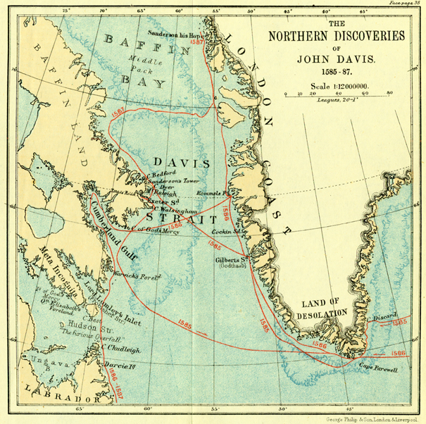
Hakluyt, Richard, 1552?-1616. Born and raised in Sandridge, in Devonshire, England, John Davis (1550?-1605) was a sharp contrast to Frobisher. His neighbors were the Gilberts [see discussion of Humphrey Gilbert under Frobisher] and their half-brother Walter Raleigh—both promoters of explorations and explorers, and favored by Queen Elizabeth. Davis's principal achievements and legacy were the detailed maps and descriptions of Arctic coasts (Greenland, Baffin Island, Labrador) and his recorded observations of ice, temperature, vegetation, and animal life obtained during his three voyages in search of a Northwest Passage [map of his expeditions, from Markham, A Life of John Davis (1889)]. His logbook for his third voyage became a model used by mariners for centuries. Pages had columns (left to right) for entering the month and day, hour, course being followed, number of leagues traveled since last entry, elevation of the pole (latitude) in degrees and minutes, direction of the wind(s), and a larger note area called “The Discourse” for narrative descriptions. He also developed (ca. 1594) the back-staff, alternatively known as the “Davis or English quadrant,” an improvement of mariners' quadrants and other early navigational instruments used for establishing latitude; it enabled the user to get his reading by turning his back on the sun. He wrote a very popular book on practical navigation, The Seamans Secrets (1594), which illustrated the use of the instrument. Davis's first expedition to discover the Northwest Passage departed from Dartmouth, England, on 7 June 1585 in two barks: the Sunshine, of fifty tons, carried twenty-three men; the Moonshine, of thirty-five tons, had nineteen.
Later, they met Greenlanders, the English musicians played, and both parties did some dancing and trading. Their voyage took them up the west coast to a latitude of about 64° N, and then they sailed northwest over Davis Strait to Baffin Island, landing at 66° 40' N, where they encountered polar bears for the first time. They continued south along the coast into what is now Cumberland Sound; cursory explorations suggested to Davis that this might be the passage he was seeking, but the lateness of the season convinced him to sail home. Both ships reached Dartmouth on September 30. Buoyed by his success, Davis tried again the next year with a larger expedition: the Mermaid (a ship of 120 tons), the two barks of the previous year, and a pinnace named Northstar (ten tons) which, carried on board the Mermaid, was to be used for scouting purposes. They left Dartmouth on 7 May 1586, and from the middle of June to the beginning of August they explored more of the southwestern coastline of Greenland, often interacting with local Greenlanders, who relentlessly tried to steal anything the explorers had that was made of iron. They encountered much ice; growing sick, some of Davis's men wanted to go home. He compromised by stocking the Moonshine and sending back the more valuable but less useful Mermaid. Davis then crossed over to Baffin Island, hitting land around latitude 66° 19' N on August 14. Till the end of the month, he sailed down the coast, noting large numbers of diverse birds and ample forests. At 54° 30' N, off Labrador, “. . . we found great abundance of cod, so that the hooke was no sooner overboord, but presently a fish was taken” [Hakluyt, p. 785]. It was the best fishing area anyone had ever seen. Landing further south, a group of his sailors went ashore, and two were murdered by natives. Stormy weather prevented them from extending their explorations, and they returned to Dartmouth in early October. In Davis's letter to his major subscriber, the London merchant William Sanderson, he reported: “I have now full experience of much of the Northwest part of the world, and have brought the passage to that certainty, as that I am sure it must be in one of four places, or els not at all” [Hakluyt, p. 786.] He asked for one more voyage, as it would not cost anything because of the assumed sale of skins, furs, and fish. Sanderson was agreeable, and so on 19 May 1587, Davis set sail from Dartmouth once again—this time with two barks, Elizabeth and Sunshine, and a smaller, clinker-built boat called Ellen. In June, disagreements arose between Davis and the mariners on the barks: they preferred to fish and stay together, and wanted to shape their own course. After much talk and many threats, they reached the west coast of Greenland, where they encountered some thievish natives. On June 21 Davis decided to divide the group; for commercial reasons he permitted the two barks henceforth to pursue a fishing voyage while he vowed to continue his exploration northward in the leaking and inelegant Ellen (“at Sea she was like to a cart drawen with oxen”) with whoever would join him.
On June 30 they attained their high latitude of 72° 12' N on the west coast of Greenland, which they named Hope Sanderson. Heading west into the open sea about 120 miles, they came upon the middle pack ice of Baffin Bay and, after several days of drifting with it and working around it, reached Baffin Island once again. Southward, the coast became familiar. This time they explored Cumberland Gulf more thoroughly, named Lumley's Inlet (the position of which agreed with Frobisher Strait), and came across what would later be known as Hudson Strait.
During August they coasted along Labrador to a latitude of about 51 N till, low on fresh water and wood, they hastened home. They arrived back in Dartmouth on 15 September 1587. Though he failed in his voyages to find the Northwest Passage, Davis found the sea open far to the north and was convinced, as he wrote to his major subscriber, the London merchant William Sanderson, that a “passage is most certaine, the execution most easie . . .” [Hakluyt, p. 792. ]. Writing centuries later, the biographer Clements Markham judged Davis's efforts highly:
|
||||||
|
Exhibition Links
|