The Strait of Magellan: 250 Years of Maps (1520–1787)
The Strait of Magellan is a 350-mile navigable passage between the Atlantic and Pacific oceans located at the southern extremity of South America. It separates the mainland of Patagonia from the archipelago of Tierra del Fuego, the eastern part of which today belongs to Argentina, the western and southern parts, including Cape Horn and its surrounding islands, to Chile. But there is nothing straight nor straightforward about the passage; rather, it is a maze of islands, bays, and channels. (See the very detailed Schrämbl map of 1787.)
The existence of such a strait was suggested on world maps as early as 1507, when the German cartographer Martin Waldseemüller issued his landmark wall map bearing, for the first time, the name America. Portuguese explorer Ferdinand Magellan was the first European to “discover” (confirm) the passage during his expedition’s historic circumnavigation of the world (1519–22); he claimed to have seen such a strait on a chart in the treasury of King Manuel I of Portugal. Tierra del Fuego was considered to be part of a larger, unexplored southern landmass; hence, the strait was the only transoceanic route mariners could follow. (See the Quad map of 1600.)
Magellan’s 1520 transit of the strait took thirty-eight days, many of them spent scouting and discounting alternative paths through the labyrinth. The following expedition in 1525, led by the Spanish nobleman Garcia Jofre de Loaísa, required four and a half months to solve the strait’s puzzle. As a result, the commander recommended that Spain abandon using the route to reach the Pacific. Henceforth, most Spanish expeditions to the Pacific were launched from their ports on the western coasts of Central and South America.
The first English venture through the passage—in a speedy seventeen days—was that of the privateer and circumnavigator Sir Francis Drake in 1578. Exiting into the Pacific, his expedition met fierce winds that pushed his ships south and east to a latitude of about 57° S, where they were surprised to find open water. (Later, this serendipitous discovery was named the Drake Passage; it offered the possibility of a more southern route around South America.)
The discovery of the Le Maire Strait and Cape Horn by the Dutch mariners Jacques Le Maire and Willem Corneliszoon Schouten in 1616 at last provided explorers and merchants with a viable alternative to the vagaries of the Magellan Strait. It was not until 1624 that another Dutch explorer, Jacques L’Hermite, charted the islands and waters around the cape, proving that Cape Horn was really an island. (See the Hondius and Blaeu maps of 1635.) Rounding Cape Horn, of course, would prove to have serious weather issues of its own—ones that continue to confront and confound sailors today—but it would become the preferred transoceanic route for sailing ships for centuries to come.
[Click on the maps below for high-resolution images]

1520: Pigafetta, Antonio, ca. 1480/91–ca. 1534. “Figure of the Pathagonian Strait. Of the region of Pathagonia. Ocean Sea. Of the Pacific Sea. And Other Capes.” From volume 2 of Magellan’s Voyage: A Narrative Account of the First Circumnavigation. Translated and edited by R. A. Skelton (New Haven, Conn., 1969). Shown with permission of the Beinecke Rare Book & Manuscript Library [Rare Books Division].
The first map of the Magellan Strait (in facsimile, oriented south-north) from the first documented European transit.
[October 21, 1520] After going and setting course to the fifty-second degree toward the said Antarctic Pole, on the festival of the eleven thousand virgins, we found by miracle a strait which we called the Cape of the Eleven Thousand Virgins [the cape at the eastern end of the Strait of Magellan, at 52°20′ S]. Which strait is in length one hundred and ten leagues, which are four hundred and forty miles, and in width somewhat less than half a league. And it falls into another sea called the Pacific Sea. And it is surrounded by very great and high mountains covered with snow. (1:51)

1600: Quad, Matthias, 1557–1613. “Chica sive Patagonica et Australis Terra, MDC.” Copperplate map, with added color, 2 maps on 1 sheet, 22 × 28 cm. With contemporary manuscript annotation in bottom border. From Quad’s Geographisch Handtbuch. . . . Cologne, 1600. Reference: Martinic, Cartografía magallánica, VIII, 29. [Historic Maps Collection]
Two maps, two different projections. (This is a copy of Corneille Wytfliet’s map of 1597, which appeared in his Descriptionis Ptolemaicae augmentum,but adds a key to the lower map.) The top map, in a flat projection, shows the Strait of Magellan dividing Patagonia from Terra Australis, or the unknown southern land. (See the Terra Australis box in the Pacific Ocean section.) Victoria, Ferdinand Magellan’s ship, is sailing toward it.
The bottom map shows Terra Australis, on a polar projection, with four peninsulas: one facing Patagonia (the subject of the upper map), one opposite Africa’s southern point, one below Java, and one confronting New Guinea. These peninsulas, and the mountains and rivers portrayed on the continent, are mere conjecture. The seven-point key on the left offers possible sources. The Solomon Islands, first discovered in 1568 by the Spanish explorer Alvaro de Mendaña de Neira (1542?–95) and then lost for two hundred years, figure prominently in this map’s ocean and are correctly located next to New Guinea. (For more on the Solomon Islands, see Mendaña/Queirós in the Explorers section.)

1602: Bertius, Petrus, 1565–1629. “Fretum Magellanicum.” Copperplate map, with added color, 9 × 12 cm. From Bertius’s Tabularum geographicarum contractaru, Amsterdam, 1602. Reference: Martinic, Cartografía magallánica, VIII, 28. (See the map on the catalogue’s title page.) [Historic Maps Collection]
Published before the Dutchmen Jacques Le Maire (1585–1616) and Willem Corneliszoon Schouten (d. 1625) rounded Cape Horn (1616), the map shows the Strait of Magellan separating Patagonia and Tierra del Fuego, which still was considered to be part of a vast southern continent. The charm of the map lies in its depiction of Patagonian giants, the mythical race of large people first mentioned by Antonio Pigafetta in his chronicle of Ferdinand Magellan’s voyage. (See the Patagonian Giants box in this section.) Bertius’s note next to the illustration states that the giants can reach ten feet in height and that they paint their bodies in various colors from diverse herbs.

Oriented with north to the right, the map explodes the long-held belief that Tierra del Fuego was attached to a southern continent. Fifteen years after the circumnavigation of Le Maire and Schouten, Hessel Gerritszoon, the official mapmaker for the Dutch East India Company, is able to show the alternative route navigators can take to reach the Pacific from the Atlantic: around Cape Horn via the Strait of Le Maire. Note that Cape Horn here is still a cape, not an island. Although there is a tentative passage dotted in between San Sebastían Bay on the coast and the Magellan Strait—later proved fictitious—there is no suggestion yet of the Beagle Channel. That discovery would have to wait for two hundred years, until the HMS Beagle’s first voyage (1826–30) under English Captain Robert FitzRoy. (Naturalist Charles Darwin joined the ship on its second voyage, 1831–36.)

1635: Hondius, Jodocus, 1594/5–1629. “Freti Magellanici ac novi freti vulgo Le Maire exactissima delineatio.” Amsterdam, 1635. Copperplate map, with added color, 37 × 48 cm. Reference: Martinic, Cartografía magallánica VIII, 97. [Historic Maps Collection]
1635: Blaeu, Willem Janszoon, 1571–1638. “Tabula Magellanica: Quâ Tierrae del Fuego, cum celeberrimis fretis a F. Magellano et I. Le Maire detectis novissima et accuratissima descriptio exhibetur.” Copperplate map, with added color, 39 × 51 cm. From Blaeu’s Toonneel des aerdriicx . . . (Amsterdam, 1635). Reference: Martinic, Cartografía magallánica VIII, 98. [Historic Maps Collection]
Two of the most decorative maps of the Magellan Strait, from the golden age of Dutch cartography, the seventeenth century, from two of the most famous mapmaking families, Hondius and Blaeu. Though published in the same year, the maps differ substantially in the shape of Tierra del Fuego and the representation of Cape Horn, with Blaeu’s following outdated cartography. They both share the same table, keyed to points in the strait, for example, a penguin island (a) and a new strait (R,S,T). However, Blaeu’s map continues the idea that Cape Horn is the promontory of a cape, whereas Hondius’s map correctly presents it as an island, following the 1624 confirmation by fellow countryman, Admiral Jacques L’Hermite (1582–1624). Moreover, Hondius shows how the northwestern peninsula of Tierra del Fuego breaks up into islands; here, also, the slanting of the territory begins to mirror the true shape of the land. Blaeu’s map is notable for its scale, which illustrates how, with Mercator’s projection, distances increase toward the poles. Several Fuegians, naked or scantily dressed, stand next to it, reflecting what explorers had reported with both shock and surprise—that the natives of the territory appear comfortable in frigid weather with nothing on. To his credit, Blaeu has deleted any reference to Patagonian giants, while Hondius’s map still bears a note claiming they exist.

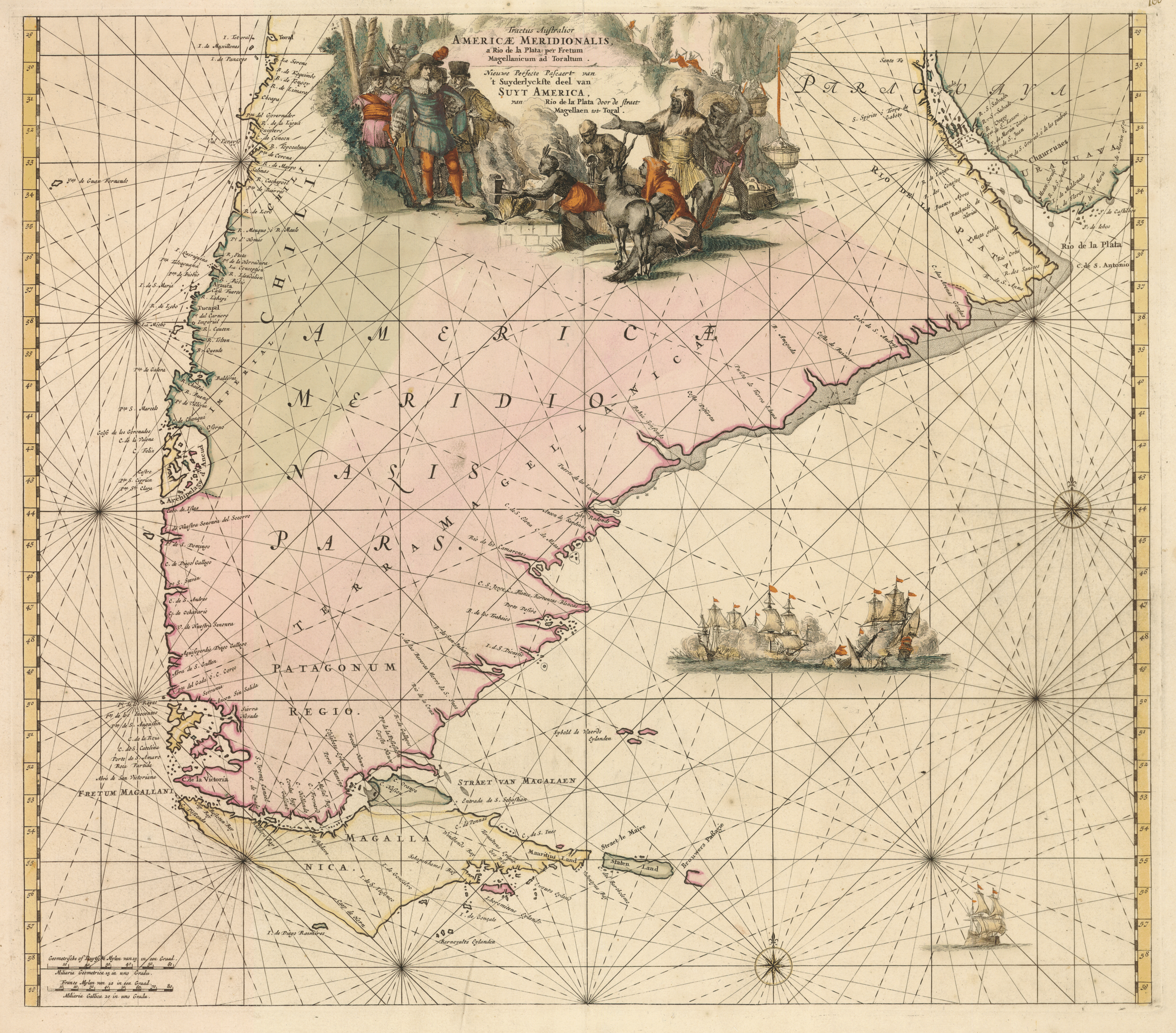
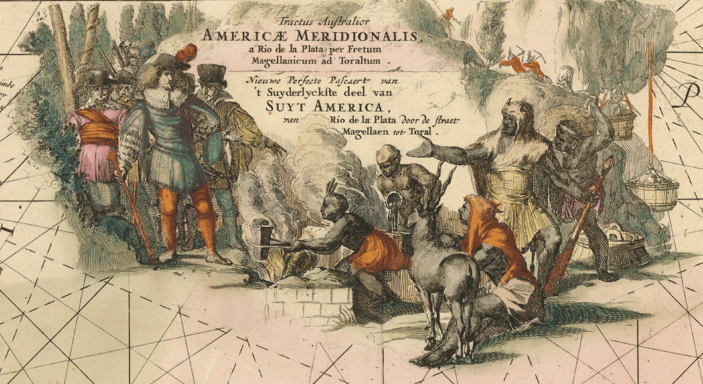
1675: Wit, Frederik de. “Tractus australior Americæ Meridionalis, a Rio de la Plata per Fretum Magellanicum ad Toraltum.” Copperplate map, with added color, 48 × 54 cm. From Wit’s Orbis maritimus ofte zee atlas. Amsterdam, 1675. Acquired with funds provided by the Friends of the Princeton University Library. Reference: Martinic, Cartografía magallánica VIII, 121. [Historic Maps Collection]
One of the most elegant and detailed charts of southern South America produced in the seventeenth century. The map continues the now archaic, headland view of Cape Horn but offers a much fuller picture of the west coast of Chile, identifying many capes and ports. In the Atlantic, an unspecified Dutch naval battle takes place. The dramatic cartouche, however, is the tour de force of the map (see the map detail): a meeting between Dutch merchants and natives (Patagonians or Fuegians?) who are mining, refining, and molding what appears to be gold. The onlooking animal with the spiral horns looks like a blackbuck antelope, native to India, or even an eland or oryx from Africa—but is out of place in South America. At the time of this map, the continent was a literal gold mine for Spain, and Dutch commercial interests were focused on the East Indies. Hence, this iconography seems incongruous: one would expect to see Spanish conquistadors and Peruvian Indians portraying their contemporary master/subject roles. Here, the scene suggests that a new deal or trade could be made. Perhaps the artist/cartographer is dramatizing the possible rather than the status quo in a work of Dutch propaganda.
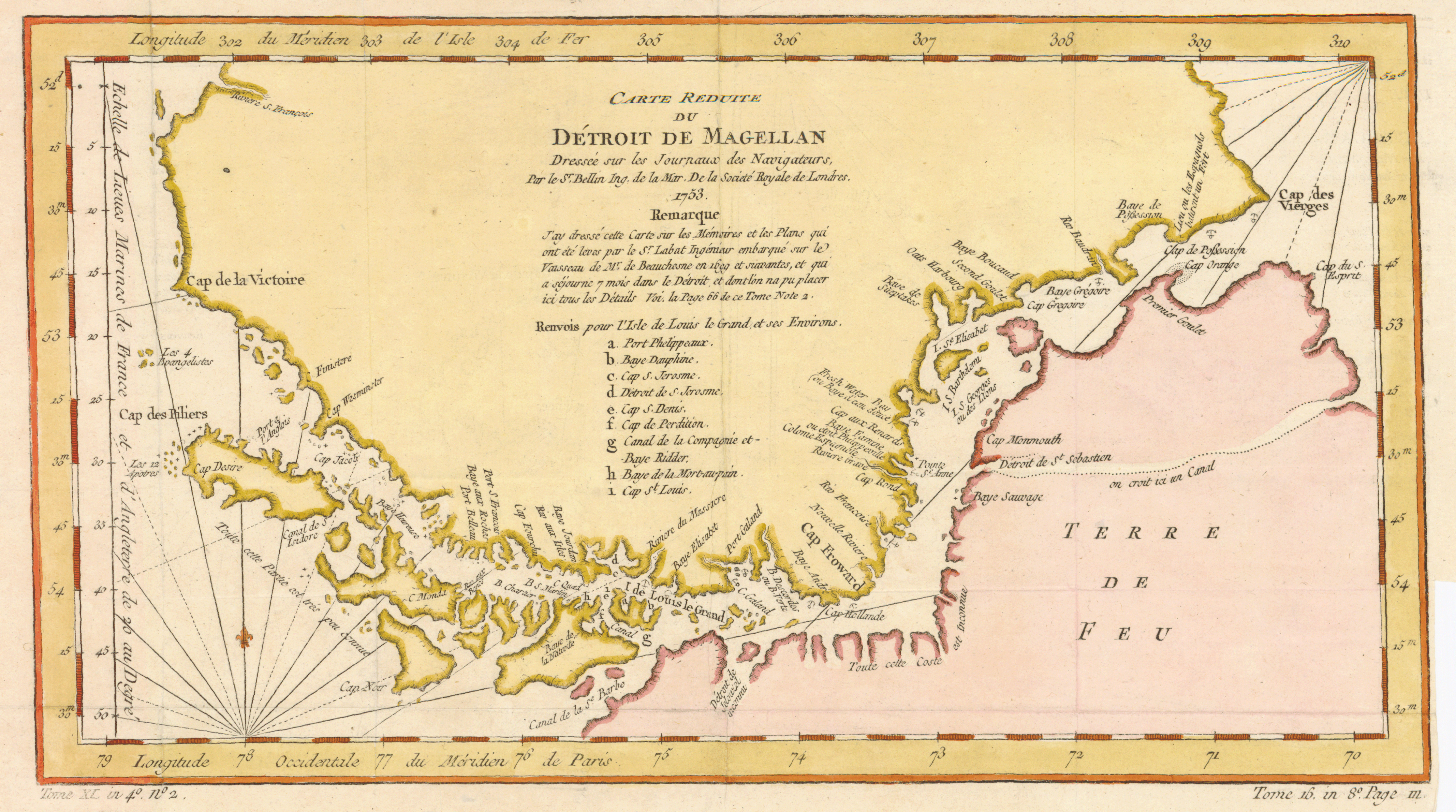
1753: Bellin, Jacques Nicolas, 1703–1772. “Carte réduite du Détroit de Magellan: Dressée sur les journaux des navigateurs.” Copperplate map, with added color, 17 × 33 cm. Probably issued in l’abbé Prévost’s Histoire générale des voyages . . . (Paris, 1746–1770). Reference: Martinic, Cartografía magallánica VIII, 301. [Historic Maps Collection]
A number of islands in the strait, as well as the capes they confront on the mainland of Patagonia, find identities here. (Outside the central thoroughfare, however, not much is known—“Toute cette Partie est trés peu connue”—more than two hundred years after Magellan’s first transit.) As the center text explains, the map is based on information obtained firsthand by a monsieur “Labat,” who traveled with an expedition (1698–1701) commanded by the French naval captain Jacques Gouin de Beauchêne (1652–1730). The trip was funded by a Crown-backed, nobility-financed French company seeking to establish colonies and trade in countries of South America that were not already occupied by Europeans. Arriving in the Strait of Magellan on June 24, 1699, in the middle of a rather mild winter season, the men tentatively explored islands and shores, interacting with the natives who welcomed them. Finding the climate as temperate as France, Beauchêne felt that a settlement might be possible there. The ships’ principal home during this time was Port Phelippeaux (named after the captain’s ship) on l’Isle de Louis le Grand(named for the French King Louis XIV, but known today as Isla Carlos III), shown as a on the map. Strong westerly winds prevented them from leaving the strait till January 21, 1700, after a seven-month sojourn. They traveled up the Spanish-controlled coast of Chile and Peru and visited the Galápagos Islands, but found little else to recommend to their sponsors. While returning to France, via Cape Horn, in 1701, they stumbled upon the most remote island in the Falklands archipelago, which they called Beauchene, its name today.

1787?: Bonne, Rigobert, 1727–1794. “Détroit de Magellan: Avec les plans des principaux ports, bayes, &c. de ce détroit.” Copperplate map, with added color, 23 × 34 cm. Probably from R. Bonne and N. Desmarest’s Atlas encyclopédique . . . (Paris, 1787–1788). Reference: Martinic, Cartografía magallánica VIII, 346. [Historic Maps Collection]
Benefiting from the voyages of Englishmen John Byron (1723–1786), Samuel Wallis (1728–1795), and Philip Carteret (d. 1796), this French chart offers an updated view of the passage through the strait—from C. des Vierges on the Atlantic side to C. Victoire on the Pacific. (For more on Wallis and Carteret, see the Explorers section.) Sixteen insets within the upper and lower margins of the map provide detailed plans of ports, harbors, and bays along the route, including soundings, points of reference, and anchorages.

1787: Schrämbl, Franz Anton, 1751–1803. “Karte der Magellanischen Strasse.” Copperplate, with added color, 50 × 67 cm. Probably issued in Schrämbl’s Allgemeiner grosse Atlas (Vienna, 1786–1800). Reference: Martinic, Cartografía magallánica, VIII, 412. [Historic Maps Collection]
An Austrian version of a map first printed in Madrid in 1769 by Don Juan de la Cruz Cano y Olmedilla (1734–1790) of the Royal Academy of St. Fernando, then enlarged and improved by Thomas Jefferys (d. 1771), geographer to King George III, and included by map and printsellers Robert Sayer and John Bennett as the last map in their influential American Atlas (London, 1776). The Madrid-London-Vienna route of the map reflects the interactive, snowballing nature of the European map trade of the period, where to borrow, embellish, and repackage was the norm. This map adds some topography (forests and mountains) and a number of illuminating notes about native populations and the landscape. Examples (here, taken from the English edition): “Indian Hutts—These Indians are of a good size; they cross the Straits in Canoes made with the Bark of Trees.” “A Warlike Nation.” “A Deep Valley with Woods & fine Meadows.” “Indian Hutts—the Indians of this Cast Light fires when they see a ship.” “A Volcano Cover’d with Snow.” “A Great Mountain which is a Sea Mark.” “Channels and Openings according to the Modern Geographers.” These latter will prove to be only bays and inlets as maps of the region slowly and gradually improve over the years. Because of its geographical complexity, remoteness, and extreme weather conditions, Tierra del Fuego would not be adequately mapped until the mid-1800s.