William Dampier, 1651–1715
Expedition (1699–1701): One ship (Roebuck), 50 men
Charge (by British Admiralty): To explore the east coast of New Holland (Australia)
Accomplishments: Instead explored the west coast of Australia, discovered and named New Britain, and made the first detailed record of Australian flora and fauna
Legacy of Dampier’s name: Dampier Archipelago, Dampier Land, Dampier Strait (all near Australia)
[Click on the images below for high resolution versions.]

Portrait of William Dampier. From C. I. Johnstone’s Lives and Voyages of Drake, Cavendish, and Dampier, Including an Introductory View of the Earlier Discoveries in the South Sea, and the History of the Bucaniers (New York, 1832) [General Library Collection]
What do the words avocado, barbecue, breadfruit, cashew, catamaran, and chopsticks have in common? They, and hundreds of others, were introduced into the English language by the explorer/naturalist/buccaneer William Dampier. Though he has been largely forgotten, Dampier was the most important English maritime adventurer of the seventeenth century: he was the first person to circumnavigate the world three times, the first Englishman to reach and map parts of Australia and New Guinea, and the first English best-selling travel writer. Bookended by the careers of Sir Francis Drake in the 1500s and Captain James Cook in the 1700s, Dampier's exploits fused the rakish plundering of the former with the scientific inquiry of the latter. His contributions were numerous and his influence far-reaching.
Little is known of Dampier’s early life, except that he was born in East Coker, Somerset, England, the second son of a tenant farmer, and received a good, basic education that included Latin and arithmetic. By age seven, he had lost both parents and was apprenticed to a shipmaster—beginning a lifelong love of the sea. He sailed to France and to Newfoundland; by 1670, he was sailing to Java in the East Indies by way of the Cape of Good Hope, learning the art of navigation and studying the patterns of wind and weather that would become his forte. A major part of his early life was spent in the Caribbean region, ultimately joining buccaneers in their raids on Spanish shipping, then sailing with privateers around South America to continue attacks on the Spanish along the continent’s west coast. He crossed the Pacific to the Philippines and Spice Islands (Moluccas), explored the northwest coast of New Holland (Australia), was marooned in the Bay of Bengal, and finally
returned, penniless, to England in 1691, having completed his first circumnavigation. After all of this, he still had his journals.
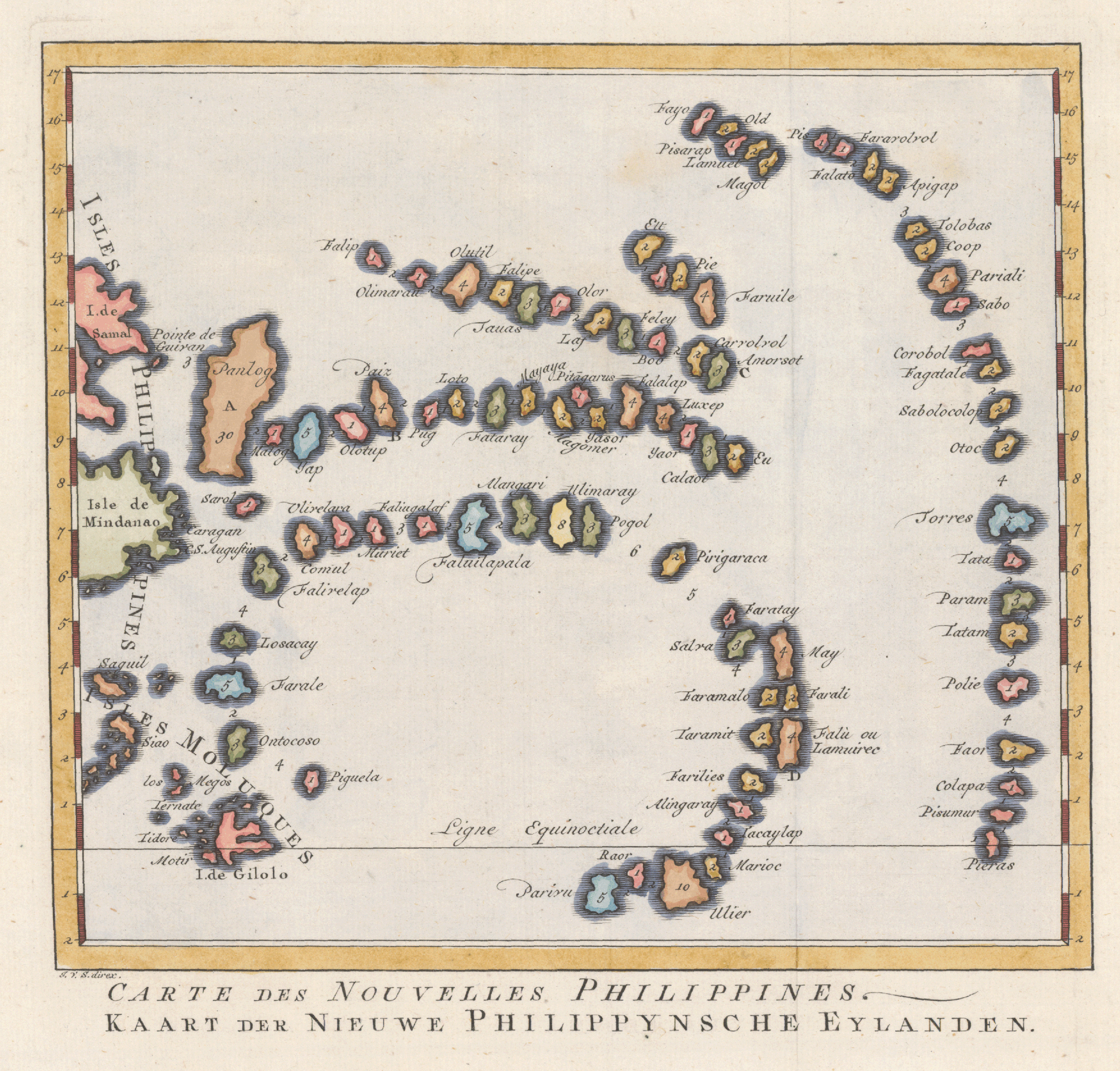
Bellin, Jacques Nicolas, 1703–1772. “Carte des Nouvelles Philippines” (Paris, 1757). Copperplate map, with added color, 18 × 20 cm. [Historic Maps Collection]
A curious map of Palau, including some of the area traversed by Dampier in the 1680s. Born in Bohemia, Jesuit Pavel Klein (Pablo Clain) arrived in the Philippines in 1682. He is credited with putting Palau on the map for Europeans, a sketch of which accompanied a letter he sent to his superior in 1697. In it, he described how a group of natives had been stranded on the northern coast of the Philippine island of Samar in December of the preceding year. The natives used a set of 87 pebbles to describe their islands, indicating in numbers the days needed to sail around or between them. Klein's letter and map were frequently reprinted, bearing the natives' inconsistencies in spelling and inaccuracies in location. [For more, see Augustin Krämer's Palau volume 1 in G. Thilenius, Results of the South Seas Expedition, 1908-1910, Hamburg, 1917.]
Dampier’s book about his exploits, A New Voyage Round the World (1697), was a unique combination of seafaring adventure and natural history not seen before, which the public loved and the Royal Society respected. In his preface, he acknowledged that he was “Choosing to be more particular than might be needful, with respect to the intelligent Reader, rather than omit what I thought might tend to the information of persons no less sensible and inquisitive, tho not so Learned or Experienced.” And without vanity, he boasted that the reader could “expect many things wholly new to him.” In 1699, Dampier followed it with Voyages and Descriptions, which contained a significant technical work, “A Discourse of Trade-Winds, Breezes, Storms, Tides, and Currents.” Included for the first time were maps of the winds across all the world’s oceans, produced from his own experience. (See one of Dampier’s wind maps in
the Pacific Winds box in the Pacific Ocean section.)
The buzz about Dampier’s first volume reached the British Admiralty. It offered him a sinecure at the customs house and invited him to propose an expedition that would honor the nation. Dampier countered with the idea of a voyage to Terra Australis, which still appeared on maps as an undefined, mythical, southern continent. (For more on this, see the Terra Australis box in the Pacific Ocean section.) He would start the search by proceeding to New Holland from the east. But he wanted a free hand, three years of supplies, and two ships. The Admiralty offered him a fifth-rate warship named the Roebuck and fifty men.
So the Roebuck approached New Holland from the west instead of the east, reaching the continent on August 1, 1699. They first made landfall at today’s Shark Bay, then proceeded northward for a month, during which time Dampier made a thorough scientific record of the area’s flora and fauna. His only encounter with Aborigines turned into a frightening skirmish in which he probably killed a man with his gun. In September, the ship sailed to Timor and then around the northern coast of New Guinea, where it encountered menacing natives every time the crew attempted a landing. On March 24, they entered a strait at the easternmost part of New Guinea that no voyager had previously noted; to the east was more land. Dampier had discovered new territory, which he called Nova Britannia, or New Britain. He could have sailed southward to fulfill his original plan of surveying the eastern coast of New Holland, but the Roeb uck was worm-eaten, and the men were anxious to get home.

“New Holland.” Views from Dampier’s A Voyage to New Holland . . . (London, 1703). [Rare Books Division]
After leaving Brazil, Dampier and his men had spent more than three months at sea, traveling without stop, more than one-third of the way around the world. He describes first sighting the Australian continent from the west:
When it was day we steered E.N.E. with a fine brisk Gale; but did not see the Land till 9 in the Morning, when we saw it from the Topmast-head, and were distant from it about 10 Leagues; having then 40 Fathom water, and clean Sand. As we ran in, this day and next, we took several Sights of it, at different Bearings and Distances; from which it appear’d as you see in [Table IV. 1,2,3,4,5]. . . . This Morning, August the first [1699] . . . [w]e strove to run in near the Shore to seek for a Harbour to refresh us after our tedious Voyage; having made one continued stretch from Brazil hither of about 114 Deg.; designing from hence also to begin the Discovery I had in mind to make on N. Holland and N. Guinea. [pp. 117–18]

Dampier as Ornithologist
Birds seen on the coast of New Holland. From Dampier’s A Voyage to New Holland . . . (London, 1703). [Rare Books Division]
There were but few Land-Fowls: we saw none but Eagles, of the larger sorts of Birds; but 5 or 6 sorts of small birds. The biggest sort of these were not bigger than Larks; some no bigger than Wrens, all singing with great variety of fine shrill Notes; and we saw some of their Nests with young Ones in them. The Water-Fowls are Ducks, (which had young Ones now, this being the beginning of the Spring in these Parts); Curlews, Galdens, Crab-catchers, Cormorants, Gulls, Pelicans; and some Water-Fowl, such as I have not seen any where besides. I have given the Pictures of several Birds on the Coast. [pp. 122–23]

Dampier as Botanist
“Plants found in New Holland.” From Dampier’s A Voyage to New Holland . . . (London, 1703). [Rare Books Division]
Tab. 3. Fig. 3. Of what genus this Shrub or Tree is, is uncertain, agreeing with none yet describ’d, as far as can be judg’d, by the State it is in. It has a very beautiful Flower, of a red colour as far as can be guess’d by the dry Specimen, consisting of ten large Petals, hoary on both sides, especially underneath; the middle of the Flower is thick set with Stamina, which are woolly at the bottom, the length of the Petals, each of them crown’d with its Apex. The Calix is divided into five round pointed parts. The Leaves are like those of Amelanchier Lob. green a top and very woolly underneath, not running to a point, as is common in others, but with an Indenture at the upper end. [p. 158]

Dampier as Ichthyologist
Fish taken on the coast of New Holland. From Dampier’s A Voyage to New Holland . . . (London, 1703). [Rare Books Division]
[Fig. 5] This is a Fish of the Tunny kind, and agrees well enough with the Figure in Tab. 3 of the Appendix to Mr. Willughby’s History of Fishes under the Name of Gurabuca; it differs something, in the Fins especially, from Piso’s Figure of the Guarapucu. [p. 162]
Book:
Dampier, William, 1652–1715. A Voyage to New Holland, &c. in the Year 1699. . . . Vol. 3. London, 1703. Gift of Bernard Kilgore. [Rare Books Division]
Dampier’s important third work, the result of his voyage of exploration and discovery aboard the Roebuck.
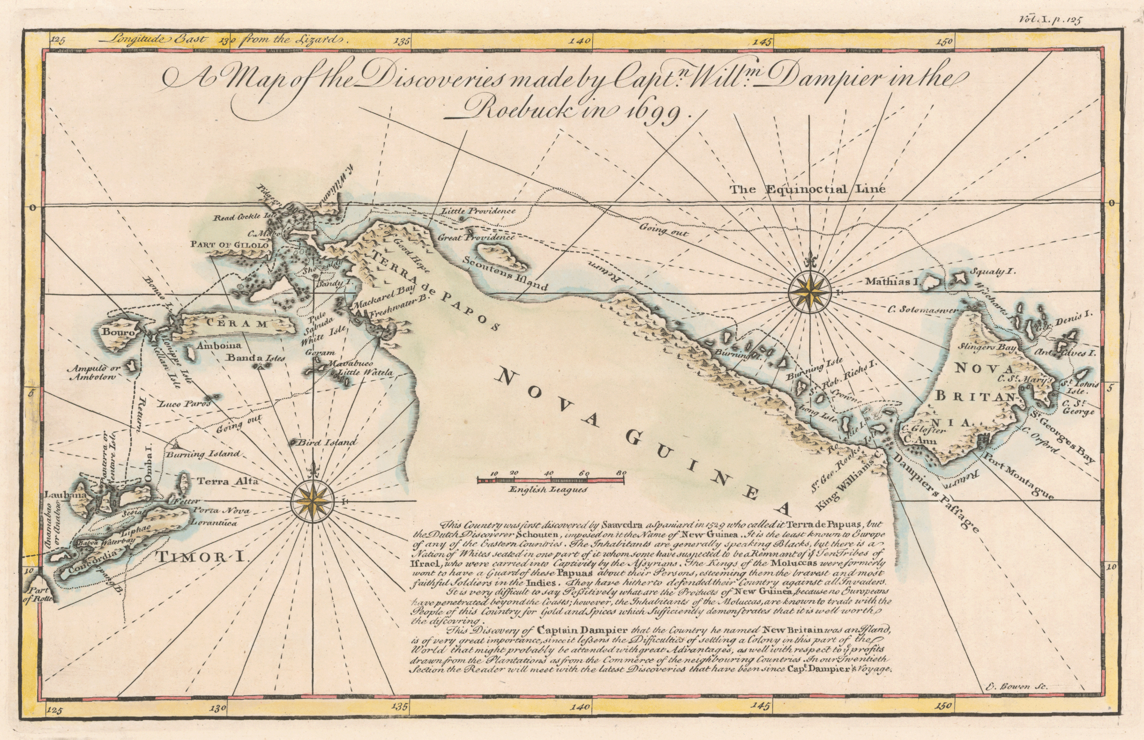
Bowen, Emanuel. “A Map of the Discoveries Made by Captn. Willm. Dampier in the Roebuck in 1699.” Copperplate map, with added color, 19 × 31 cm. From John Harris’s Navigantium atque itinerantium bibliotheca, or, A Complete Collection of Voyages and Travels (London, 1744). [Historic Maps Collection]
A mixture of fresh, detailed cartography and revealing commentary. Dampier’s discovery of a strait separating New Guinea from the island he named New Britain has colonial significance, according to the note on the map: “Since it lessens the Difficulties of settling a Colony in this part of the World that might probably be attended with great Advantages, as well with respect to ye profits drawn from the Plantations as from the Commerce of the neighbouring countries.” New Guinea, however, is the “least known to Europe of any of the Eastern Countries.” As a result, Western imagination had been running wild: it is stated that most of the inhabitants are “Blacks, but there is a Nation of Whites seated in one part of it whom some have suspected to be a Remnant of ye Ten Tribes of Israel, who were carried into Captivity by the Assyrians.” Practically speaking, it is difficult to “say Positively what are the Products of New Guinea because no Europeans have penetrated beyond its coasts.” This latter statement still rings true, for, after 250 years, despite repeated European attempts at domination (Dutch, German, English), the large island country remains remote, recalcitrant, and reclusive. Probably the most telling discovery took place on August 4, 1938, when American zoologist Richard Archbold came upon the Grand Valley of the Baliem River, where fifty thousand yet-undiscovered Stone Age farmers were living in orderly villages. Known as the Dani, the people were the last large society to make first contact with the rest of the world.
Dampier’s route back to England took the ship to the Dutch port of Batavia on Java and then, joining a convoy of European ships, to the Cape of Good Hope, and St. Helena. By that time, the Roebuck was leaking seriously and had to be abandoned at Ascension Island. The men made tents from the sails and hunkered down until, five weeks later, they were rescued by Royal Navy vessels bound for Barbados. Once there, Dampier transferred to another ship and reached England in August 1701. He had managed to save some of his specimens and his journals. His reputation with the Admiralty, though, was tarnished forever when he was found guilty of mistreating an officer and deemed unfit to command a naval vessel. He was fined the amount of his three years’ salary.
Dampier’s standing with the scientific community remained high, however. He gave his plant specimens to Royal Society fellows and published the first volume of A Voyage to New Holland (1703), with maps and illustrations of new species of plants, birds, and fish. In his later years, Dampier made two more circumnavigations, both on privateering ventures seeking Spanish treasure ships, the second of which was fairly successful. Dampier’s share of the prize was paid two years after his death, and went toward his debts. The cause and precise date of Dampier’s death is unknown, as is his place of burial.

“Capt. Dampiers New Voyage to New Holland & c. in 1699 &c.” Copperplate map, 16 x 28 cm. From Dampier’s A Voyage to New Holland . . . (London, 1703). [Rare Books Division]