Jacques Le Maire, 1585–1616 / Willem Corneliszoon Schouten, d. 1625
Expedition (1615–1617): Two ships (Eendracht and Hoorn), 87 men
Charge (by Le Maire’s father’s Australian Company): To find a new route to the Pacific and the Spice Islands to avoid the trading monopoly of the Dutch East India Company and to find the Southern Continent (Terra Australis)
Accomplishments: Discovered the Strait of Le Maire, Staten Island, Cape Horn route around southern part of South America, some of the Friendly Islands (Tonga Islands)
[Click on the images below for high resolution versions.]
Chartered in 1602 and granted a monopoly over trade with the East Indies by the Dutch government, the Dutch East India Company (Vereenigde Oostindische Compagnie or VOC) maintained its stranglehold by controlling the two known sailing routes from Europe to the East. Without its permission, no Dutch ship could pass through the Strait of Magellan nor around the Cape of Good Hope. Isaac Le Maire (1558–1624), a wealthy merchant and one of the largest stockholders of the VOC, became disenchanted with the company’s power, for he wanted the opportunity to explore and discover new countries himself and to reap the profits from any resulting commerce. In 1610, he formed a new firm, the Australian Company, which was chartered by the government to engage in trade with China, Japan, northeastern Asia, New Holland (Australia), and South Pacific islands. Reports from Sir Francis Drake’s circumnavigation (1577–1580) had suggested a possible new route around South America, which would avoid trespassing on the rights of the VOC. (For more on the “Drake Passage,” see Drake in the Explorers section.) To pursue the idea, Le Maire joined with experienced navigator Willem Corneliszoon Schouten to mount their own expedition, raising most of the needed capital from wealthy businessmen of Hoorn, a city in northern Holland.
Le Maire’s son Jacques was put in charge; Schouten was given the role of expedition navigator. The two-ship venture (Eendracht and Hoorn) departed from Texel, North Holland, on June 14, 1615. They stopped on the west coast of Africa to pick up a load of lemons to help prevent scurvy, then sailed across the Atlantic and spent a month of rest and repair in Port Desire, on the Patagonian coast of South America. While there, the Hoorn was lost in a fire (December 19), and its crew and everything worth salvaging were transferred to the Eendracht.

Portrait of Jacques Le Maire. Frontispiece to Le Maire’s Spieghel der Australische navigatie, in Antonio de Herrera y Tordesillas’s Nieuwe werelt, anders ghenaempt West-Indien (Amsterdam, 1622). [Historic Maps Collection]
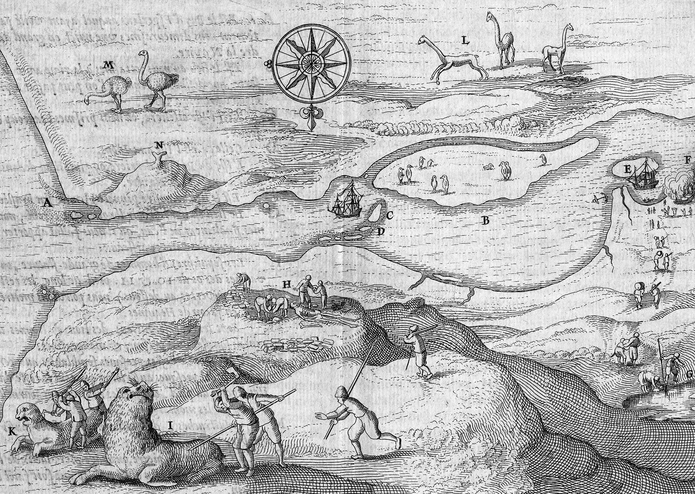
Port Desire (today’s Puerto Deseado, Argentina). From Schouten’s Diarium vel descriptio laboriosissimi, & molestissimi itineris . . . (Amsterdam, 1619). [Rare Books Division]
In December 1615, the expedition stopped in Port Desire for repairs, where the Hoorn was lost in a fire. (This refuge along the Deseado River was named by the English circumnavigator Thomas Cavendish for his ship.) This keyed illustration shows details of the area (north is at the bottom):
C, D: Islands full of birds and sea lions
E, F: Where they repaired the ships and where the Hoorn burned
G: Where they found good drinking water to carry back to the ship
H: Where they found the burial site of a giant, whose bones measured between ten and eleven feet long
I, K: How they obtained meat from the sea lions
L: Where they saw many beasts resembling deer but with longer necks and legs (guanacos) on the mountains
M: Where they saw a great number of ostrichlike birds (nandous)
N: A marvelous, natural stone post that, seen from a distance, resembles a man’s foot

Portrait of Willem Corneliszoon Schouten. From the world map in Schouten’s Diarium vel descriptio laboriosissimi, & molestissimi itineris . . . (Amsterdam, 1619). [Rare Books Division]

The surviving flagship of the Le Maire-Schouten expedition.
They proceeded southward, past the Strait of Magellan, catching sight, on January 24, of a passage about eight miles wide between two landmasses: the land on the west they called Mauriceland (today, part of Argentina’s Tierra del Fuego), that on the east Statesland (Argentina’s Isla de los Estados or Staten Island). They saw large numbers of whales, penguins, and porpoises. Great-winged birds (perhaps albatrosses), unused to seeing men, came and landed on the ship, which the men easily captured and killed. About noon on the 29th, beyond 57° S, they saw two islands lying west-southwest, which they named the Barnevelt Islands. They continued west-northwest and by evening saw land again: high, hilly slopes covered with snow, which ended in a sharp point, which they called Cape Hoorn, after Schouten’s hometown. They determined its latitude to be 57°48′ S. In cold weather, variable winds, and great billowing waves, they tacked back and forth, finally rounding Cape Hoorn (today’s Horn), in hail and rain, on January 31, 1616, for the first time in history.
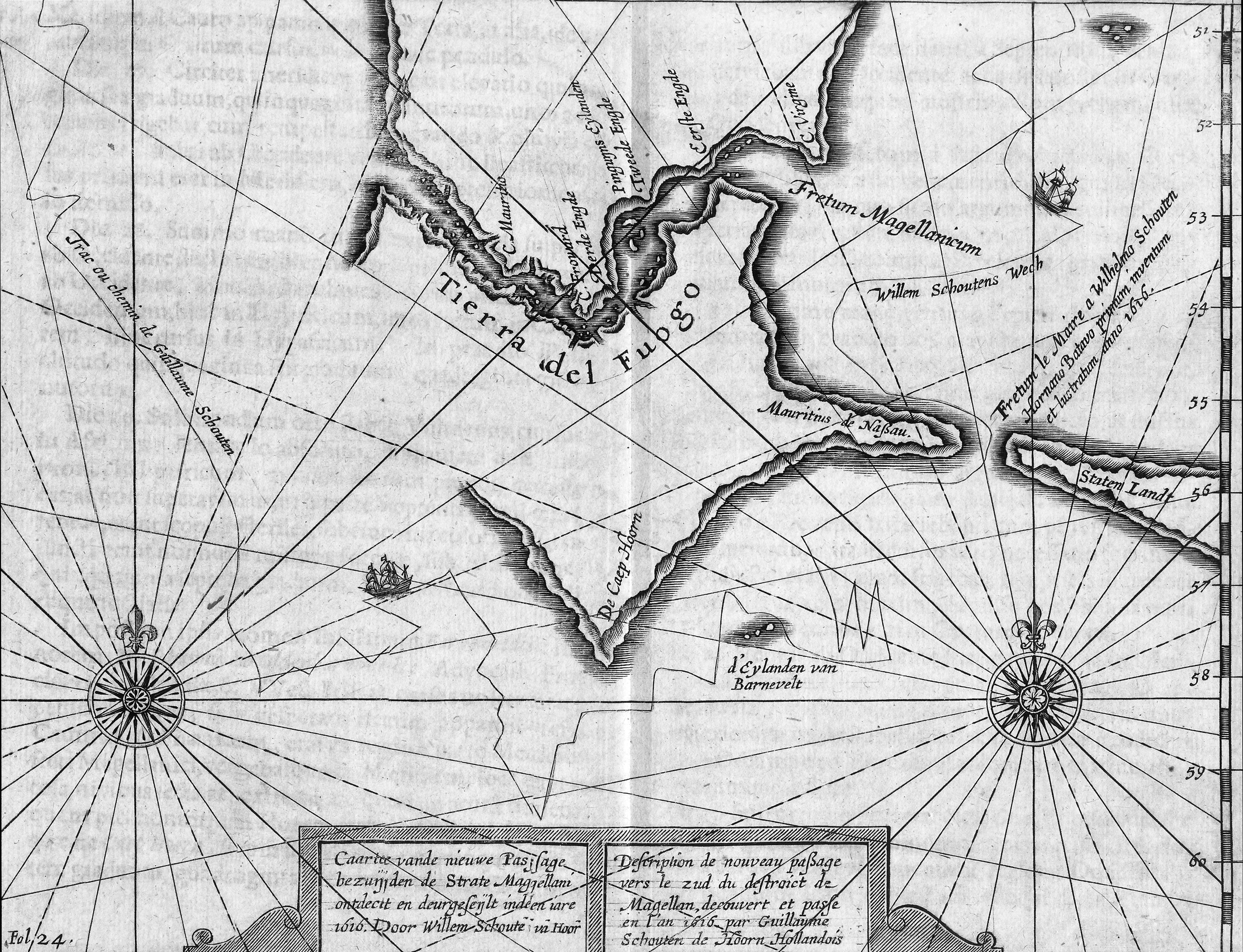
Map showing the new route around the bottom of South America discovered by Schouten and Le Maire: through the Le Maire Strait, around the Barnevelt Islands, and past Cape Horn. (Note that “Cape Hoorn” is not an island here.) From Schouten’s Novi freti, a parte meridionali freti Magellanici, in Magnum Mare Australe detectio . . . (Amsterdam, 1619). [Rare Books Division]
They had reached the South Sea and began a course up the west coast of South America. On February 12, when the western end of the Strait of Magellan lay to the east, the men toasted their good fortune, each receiving three cups of wine. Le Maire’s request that the newly discovered strait be called the Strait of Le Maire was granted, though many of the men thought the honor should have gone to their navigator, Schouten. By March 1 they were in sight of the fruitful Juan Fernández Islands. Weather and anchoring difficulties prevented them from spending much time there, however, to the grief of the men who were already sick. The ship headed west out into the vast Pacific.
In their ocean crossing, Le Maire and Schouten found and named four islands (now part of the Tuamotu Archipelago): Dog Island (where they saw several barkless dogs), Island without Ground (where they could find no anchoring ground and skirmished with the islanders), Water Island (where they found fresh water in a deep pit), and Fly Island (where the landing crew came back covered with black flies). They discovered some of today’s Tonga and Futuna Islands—and were impressed by the idyllic life lived by the natives on one of the latter that they called Hoorn Island, where the earth and sea provided everything one needed. At this time (the middle of May), knowing there was no longer any chance of finding Terra Australis in that latitude, Schouten advocated sailing north of New Guinea and proceeding to the Moluccas, a safer, known route, to which all agreed.
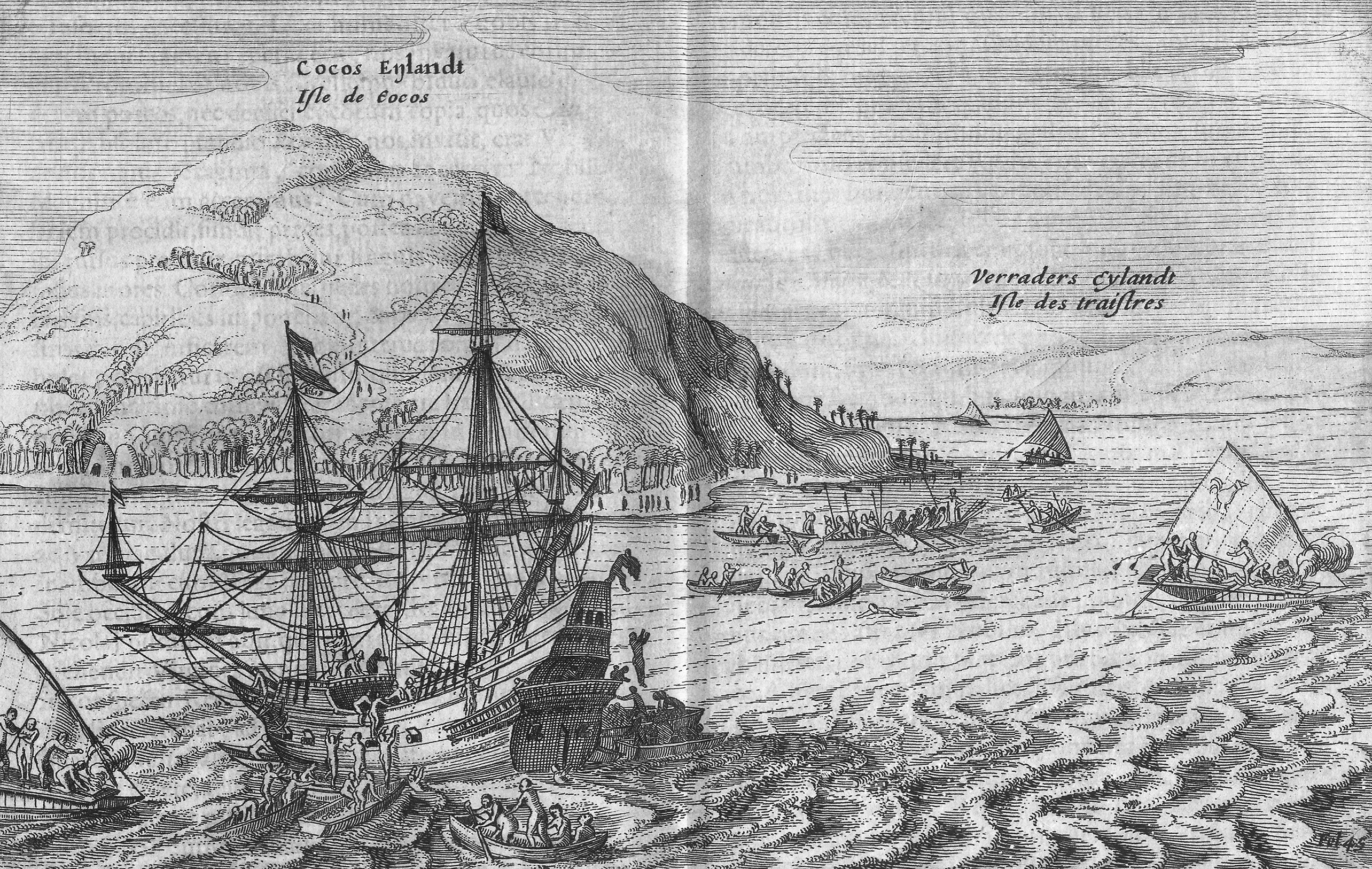
Arrival at Cocos Island (today’s Tafahi in the Tonga Islands). Named by the Dutch for its abundance of coconuts. From Schouten’s Diarium vel descriptio laboriosissimi, & molestissimi itineris . . . (Amsterdam, 1619). [Rare Books Division]

Schouten, Willem Corneliszoon. Iournael ofte beschryvinghe van de wonderlijcke reyse / ghedaen door Willem Cornelisz Schouten van Hoorn, inde jaren 1615. 1616. en 1617 . . .Amsterdam, 1618. [Rare Books Division]
Extremely rare volume, describing for the first time anywhere the discovery of a new passage around South America between the Atlantic and Pacific Oceans—thereby disproving the long-held theory that Tierra del Fuego was part of a southern continent. Thirty-eight editions of the work were printed in the Netherlands between 1618 and 1766; within a year after its first appearance in Dutch, translations in English, French, and German appeared. (Le Maire’s posthumous account was not published until 1622; see his Spieghel der Australische.)

Title page from Le Maire’s Spieghel der Australische navigatie, in Antonio de Herrera y Tordesillas’s Nieuwe werelt, anders ghenaempt West-Indien (Amsterdam, 1622). This title page bears the first printed world map to show California as an island—a cartographic concept that King Ferdinand VI of Spain officially debunked in 1747. [Historic Maps Collection]
During the summer months, the expedition sailed along, but north of, New Guinea, encountering more islands and natives, trading trinkets for food. They sighted Gilolo (Halmahera, the largest of the Moluccas) on August 11, and sailed into a safe harbor on the 19th, arriving with eighty-five of their original crew of eighty-seven men. At Ternate, on September 17, they were welcomed by ships of their countrymen. A month later, now fully equipped and stocked for the voyage home, the Eendracht arrived in Jakarta, future headquarters of the East India Company (which would rename it Batavia). Regional governor of the VOC, Jan Pieterszoon Coen (1587–1629), ordered the vessel and its cargo seized, claiming Le Maire and Schouten and their ship had violated the rights of the VOC; their objections, he argued, would have to be settled back in Holland. The men were put on VOC ships and sent homeward bound on December 14. Le Maire got sick and died en route; Schouten arrived in Zeeland on July 1, 1617.
With the help of Le Maire’s father, Isaac, Schouten pleaded their case before the Dutch legislature, ultimately succeeding (1622) and receiving compensation for the ship and its cargo. Isaac was able to retrieve his son’s diaries, which he immediately published. Thus ended, without fanfare or much honor, the saga of the greatest Dutch expedition into the Pacific Ocean.

Map showing Schouten and Le Maire’s route across the Pacific Ocean from Cape Horn on the Eendracht. From Schouten’s Diarium vel descriptio laboriosissimi, & molestissimi itineris . . . (Amsterdam, 1619). [Rare Books Division]